This classic 9 mile circular walk includes some of the most iconic landmarks and epic views in the White Peak area of the Peak District.
Distance: 15km (9.5mi) / Elev Gain: 590m (1936ft)
High Point: The Roaches - 505m
Map: OS Explorer OL24
GPS Download: The Roaches Circular
Starting Point: The Roaches UKC Parking
Route Highlights include Hen Cloud, Ramshaw Rocks, Lud’s Church and The Roaches.
This Peak District walking route covers a variety of terrain and is deceptively hilly with almost 2,000 feet of elevation gain spread out between the ascents of Hen Cloud, Ramshaw Rocks and The Roaches. With numerous great views along the way be sure to have your selfie stick or camera at the ready!
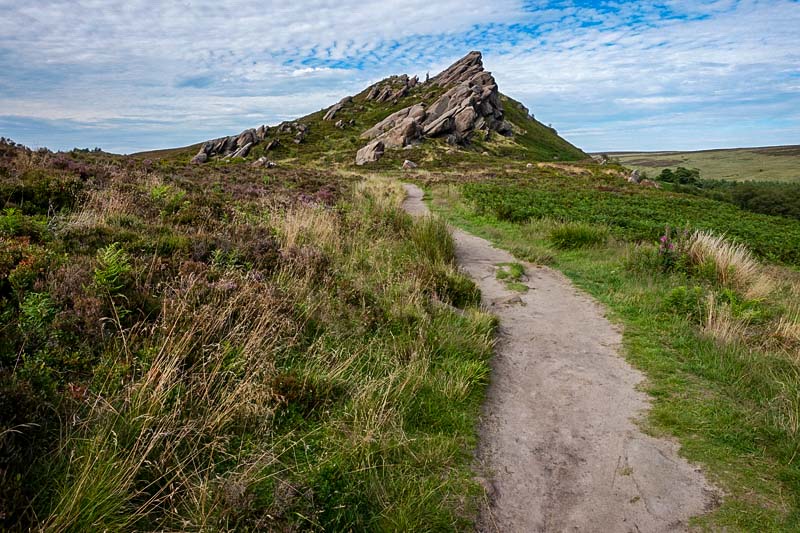
Starting from Roach Road there’s barely time to warm up as the route heads up the saddle between The Roaches and Hen Cloud. A short and sharp ascent leads to the top of Hen Cloud providing sweeping views of the surrounding landscape including The Roaches.
From the summit of Hen Cloud a descent through woodland and then farm fields is (I found) a little tricky to navigate, with the footpath (and associated signs) hard to spot in places!
The approach to Ramshaw Rocks begins just prior to the intersection with the main A53 road. The path running almost adjacent to the road was wildly overgrown, I ended up with scrapes and scratches on my shins and a couple of nettle stings as a memento of the day!
I should add, it was a warm summer day preceded by a lot of rain. The midges were out in full force and some of the paths were a little water logged.
The ascent to the distinctively shaped Ramshaw Rocks is via a direct path after crossing the subsequent minor road. The angle of the rocks is quite unique, as though the prevailing wind has beaten them into submission (I suspect there is however a more scientific explanation!) over many many years. The path is steep in places however nothing technical is encountered.
The summit ridge of Ramshaw Rocks has some impressive panoramic views, also lookout for the Winking Man rock (which I personally didn’t see, although to be fair I was running!) the shape of which resembles its namesake. The summit is actually pretty exposed, with the drop down towards the A53 a reminder that even relatively small hills can be dangerous.
From the summit of Ramshaw Rocks the next couple of miles of the route lay before you. The descent is via heather-clad moorland, the path on this occasion was super boggy in parts – though there had been a considerable amount of rain ahead of my trip which no doubt contributed to the conditions underfoot.
The route then joins a long and straight minor tarmac road for a mile or so. Once again the views are sublime, it reminded me of a scene from the Scottish borders. Over to the left a steep track seems to lead up the hillside, I believe its the home of flash brewery – one to explore another time.
The road eventually bends left then immediately right, it is here the route leaves the road.
The descent leads to farmland which must then be traversed. I’m not a big fan of crossing fields of cows, so gave them a very wide berth by sticking to the left perimeter of the fields – with my escape route (over a barbed wire fence) identified at all times!
I passed through a seemingly deserted farm then picked up a track which eventually led into Back Forest. Signs for Lud’s Church provided reassurance and the path continued on through woodland.
The actual site of Lud’s Church appeared without warning (and there was no sign as perhaps I expected). A distinctive cave-like opening in the rocks brought out my inquisitive nature – and soon enough it became clear it was indeed Lud’s Church!
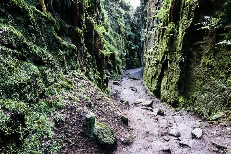
I immediately noticed the temperature drop as I entered the damp deep chasm, which was indeed impressive. I felt compelled to take numerous photos and walked the circa 100m long path in both directions to get a good feel for the place.
Heading up through and subsequently exiting Lud’s Church the route continues through Back Forest for a mile or so. As the terrain transitions from woodland to moorland the path ramps up, with the views becoming progressively more expansive – the cone shaped Shutlingsloe stands out in the distance.
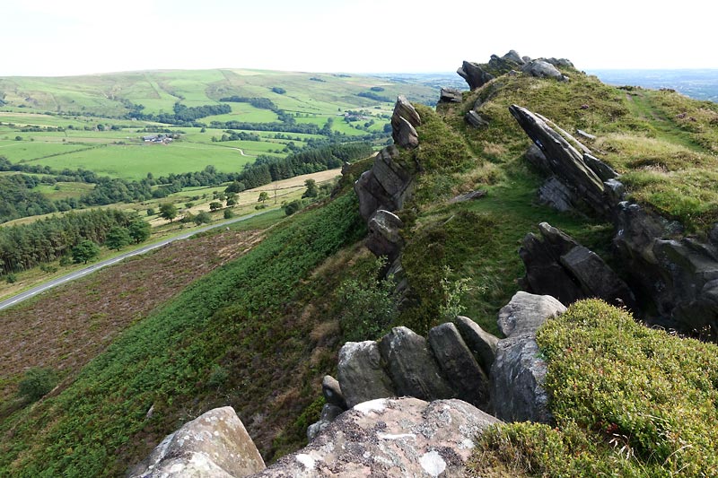
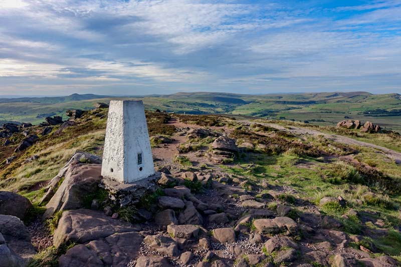
The approach path onto The Roaches is clearly visible and signed from the minor road. A stone slabbed path leads steadily up to the summit. Numerous photo opportunities present themselves, the summit trig point is a highlight along with various protruding boulders providing an interesting foreground to the lofty surrounding views.
From the summit trig and as the path descends lookout for climbers amongst the cliffs (and boulders below) – the rock climbing mecca of The Roaches is generally busy in all but wet weather. The view towards Hen Cloud is fine from here to.
The final descent off the roaches was steep in places and required some hands on action, I think I strayed off the planned route a little (as I couldn’t spot the path on the ground.
I could now see the car and soon arrived back on Roach Road via a dirt path. A great walk indeed and some ideas were already floating around in my head for next time!
Further Info
Parking – marked parking bays along Roach Road. NOTE – Arrive early (especially so on a weekend) or you may well struggle to park.
Hazards
There is some exposure on the high ground if you walk towards the edges, especially on Ramshaw Rocks and The Roaches. Bad weather can also make conditions underfoot slippy.
Remember – we cannot highlight all potential hazards when out in the great outdoors. Safety is ultimately down to you. Educate yourself in safety, weather reports, navigation and equipment specific to the activity you intend to undertake and conditions/terrain you may encounter! Check out adventuresmart.uk for general outdoor safety considerations – and activity specific guidance for hill walking, paddle boarding, mountain biking and open water swimming.