Adventure seekers need look no further than the wild and beautiful Peak District National Park. The Dark Peak to the North is an upland area dominated by exposed moorland and impressive gritstone edges. To the South the more populated White Peak is lower in altitude and known for its limestone dales. Its relative proximity to the cities of Manchester and Sheffield make the Peak District one of the most accessible and popular of the UK National Parks. With picture-postcard villages and countless vistas, once you discover the Peak District you won’t want to leave!
Adventure Highlights
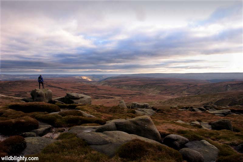
Adventure highlights include rock climbing on Stanage Edge, paragliding from Mam Tor, tackling Winnats Pass by bike and hiking Kinder Scout via the Pennine Way.
Peak District Activities


Places to Visit
To help plan your time in the Peak District we’ve covered the most popular places to visit.
Edale
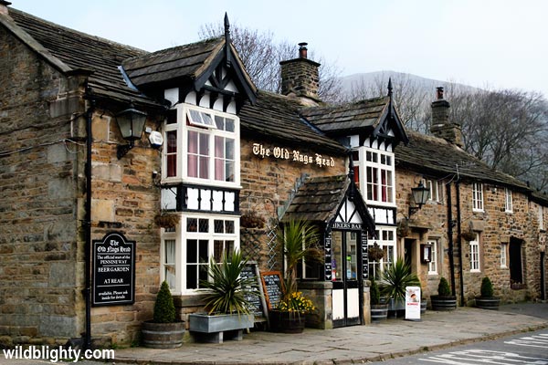
Surrounded by sweeping green countryside and majestic hills is the small village of Edale in the Derbyshire Peak District. The village is a well known walking destination, and is the official start (or end) point for the long distance pennine way walking trail. As well as walkers the village is a popular cafe stop for mountain bikers and road cyclists. A big draw-card for Edale is the train station, providing a car-free option with direct access to the great outdoors, via the super scenic Hope Valley Line which connects Manchester and Sheffield. The village itself is made up of a cluster of stone cottages and buildings, including a couple of traditional country pubs, namely the award winning Old Nags Head and The Rambler Inn. For a brew and cake head to the Penny Pot Cafe by the train station or Coopers Cafe close to the village square. If you like a leaflet wander into the visitor information centre for a chat with the friendly staff, or if you’ve run out of tea-bags there is a small general store. A great short walk from the village is to head to the summit of Ringing Roger, the somewhat towering ridge set behind the village offers sweet views of Edale and beyond. Other walking options include heading onto the Kinder plateau via Jacobs ladder (follow the signed Pennine Trail) and circling back via Ringing Roger, or heading to Mam Tor via Hollins Cross. Camping in the village is available at the Fieldhead Campsite or Coopers Campsite. If you prefer a solid roof over your head the YHA Edale is a cheap option, though its actually 1.5 miles from the village. For a more luxurious stay there are further accommodation options in and around Edale. Parking can be a problem in Edale, with the pay and display car park filling up quickly – arrive early or take the train!
Castleton
Nestled in the shadow of the impressive 517m high Mam Tor is the busy village of Castleton. Popular with tourists, walkers and mountain bikers, the village is a hive of activity on weekends and throughout the summer months.
Castleton is home to a number of show caves, which are open to visitors and offer a unique underground experience. Take an underground boat ride at Speedwell Cavern, marvel at the impressive stalactite and stalagmite formations at Treak Cliff Cavern, or head into the deep unknown at Blue John Cavern – the latter whose name comes from the semi-precious Blue John stone, which continues to be mined on a small scale.
If you like your Norman fortresses, the ruins of Peveril castle (originally built by William Peveril, son of William the Conqueror) are a steep walk up from the village. In addition to exploring the ruins there are excellent panoramic views. You may even spot a mad mountain biker taking on the white knuckle Cave Dale descent which runs adjacent to the ruins.
One of the biggest crowd pleasers in these parts is the much photographed and exceptionally beautiful Winnats Pass, a steep narrow road surrounded by towering limestone cliffs, on the edge of Castleton. Whether walking, cycling or driving this is without doubt one of the wonders of the peak district. Also not to be missed is the ‘broken road’, this now abandoned former bypass collapsed beyond repair in the late 1970s due to ongoing landslides. It has an eerie post-apocalyptic feel along with great views, and is a popular route to Mam Tor both on foot and by bike.
Castleton is a good base for shorter walks, most of which centre around the looming Mam Tor. This 517m high hill is the site of a former bronze age hill fort and offers dramatic views of the Edale valley and Kinder Plateau. The summit itself can be subject to strong winds, and its eastern slopes are a popular paragliding site. A 6 mile circular walk from Castleton incorporating Mam Tor starts from the information centre. Alternatively for a very short walk to the summit of Mam Tor you can park at Mam Nick Car Park and follow the path up through the car park towards the summit.
Around the village there are a number of pubs, cafes, outdoor shops and an information centre – the latter is by the main village car park (bring cash) and also incorporates a small village museum.
For a cheap stay in Castleton head to Pindale Farm (1 mile from the village) or YHA Castleton. Overnight camper van parking seems to be tolerated along Buxton Road, towards the bottom of the broken road. Further accomodation options in Castleton include a number of guest houses located centrally.
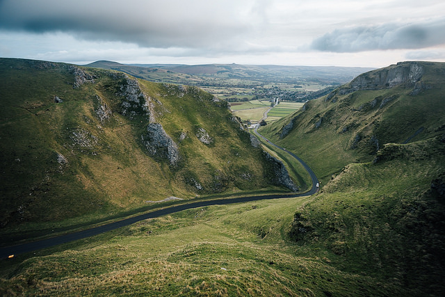
“Winnats Pass” by obsessivity.
Hathersage
The pretty village of Hathersage is set amongst a backdrop of gritstone edges and open moorland at the Eastern end of the Hope Valley. Its a popular tourist destination, especially so with climbers and hill walkers. Stanage Edge, Burbage Edge and Bamford Edge are all close by and together offer some of the best Rock Climbing in the Peak District. The compact village has a mix of outdoor shops (including alpkit), tea rooms, pubs, eateries, and local art/crafts – the majority situated along Main Rd. If heading to Hathersage be sure to pack your swimming kit – the open air heated public swimming pool is open year round and has great views – a pretty unique experience overall!
A popular local walk is to head up to the gritstone escarpment of Bamford Edge. It stands at an elevation of 1381 ft (420 metres) and has epic views over Ladybower Reservoir, Hope Valley and beyond. One could easily incorporate Stanage Edge into the walk providing a longer and equally rewarding route. Grab the OS Explorer OL1 map to plan a route!
Hathersage is directly accessible by rail, the train station is on the Hope Valley line accessible from Manchester and Sheffield with local links including Bamford, Hope and Edale.
There are a number of accommodation choices in and around Hathersage, cheaper options include YHA Hathersage and the nearby North Lees Campsite.
Buxton
Situated at 300m above sea level the spa and market town of Buxton is awash with Georgian architecture and tourist attractions, making it a popular year round destination. The town is dubbed the ‘Gateway to the Peak District’, and whilst not within the boundary of the national park is an accommodation hub for the area. Amongst the crowd-pleasers are the leafy and beautifully restored Victorian era Pavilion Gardens, the perfect place to while away an afternoon wandering or reading a book. Within the gardens are a couple of cafes and a gallery full of local arts and crafts. Buxton Opera House hosts a busy calendar of events and also includes a cinema showing the latest blockbuster films. The Crescent is a grade I listed building of architectural significance, and is currently undergoing a major transformation into a hotel and spa complex. Facing The Crescent is St Ann’s Well, a popular and free natural mineral water fountain which shares the same source as the commercially bottled Buxton water.
The main retail areas in Buxton are along Spring Gardens and the main A515 road. Cavendish Shopping Arcade off Terrace Road is also worth checking out, its housed within the original Buxton thermal baths and includes some quirky shops and original features. The Market in Buxton is held on Tuesdays and Saturdays, head to Market Place car park up the A515 from Spring Gardens. Buxton Museum and Art Gallery is a good rainy day option and is situated opposite Market Place.
Nightlife in Buxton is varied, for a chilled out evening head to Monk cocktail bar, the Buxton Brewery Tap or 53 Degrees North. If you like your micro pubs, The Ale Stop along Chapel Street serve locally brewed ales and craft ciders in a cosy setting!
Poole’s Cavern is situated within Buxton Country Park on the edge of town. Take a guided tour of the magnificent 2 million year old natural limestone caves. There is also a Go ape high ropes course within the country park.
Accommodation in Buxton is vast and varied, if you are on a tight budget Staden Grange farm (approx 4 miles from town) offer camping and glamping options in a rural setting.
Eyam
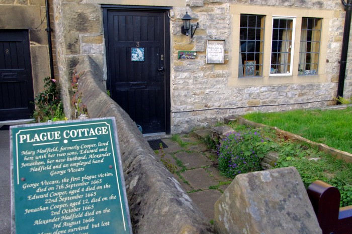
Set amongst rolling hills the former lead mining village of Eyam has a dark yet heartwarming story to tell. Back in the 1600s an outbreak of the Bubonic plague ravished almost half the village, things would have been much worse but for the villagers selfless act of self-quarantine which ultimately stopped the spread of the infection. Wander around the village and there are numerous insights into life during the plaque, including at the Museum and Church. There are a couple of cafes and a pub in the village, along with the YHA Eyam youth hostel for a cheap nights accommodation.
Eyam by Donald Judge
Peak District Facts
- The highest point in the Peak District is 636 metres, on Kinder Scout.
- Covers an area of 1,438 square kilometres.
- Became the first UK National Park in 1951.